
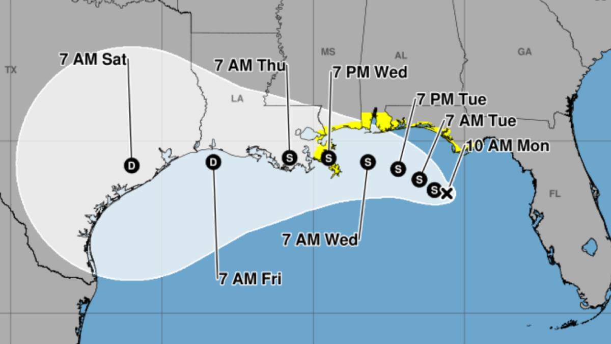

Tropical Depression Two is forecast to strengthen into Tropical Storm Bertha on Monday (July 20), with forecasters warning of heavy rain, gusty winds, and the potential for storm surge along the Gulf Coast from the Florida Panhandle to Texas. According to the National Hurricane Center, the system was centered about 120 miles south of Panama City, Florida, as of Monday morning, and is slowly moving northwestward.
The National Hurricane Center expects the depression to reach tropical storm strength later Monday, at which point it will be named Bertha—the second named storm of the 2026 Atlantic hurricane season. The maximum sustained winds were near 35 mph, as of 11 a.m ET. Once winds reach 40 mph, the storm will officially become Bertha.
The main hazards from this system are expected to be heavy rainfall and flooding. The National Weather Service forecasts two to four inches of rain along the Gulf Coast and adjacent inland areas from western Florida through southern Alabama, Mississippi, Louisiana, and the middle Texas coast through Friday, with some locations potentially seeing up to six inches or more. There is also a risk for flash flooding in urban areas, and localized totals could reach eight inches, according to the latest updates.
A tropical storm watch has been issued from the Ochlockonee River, Florida, westward to the Jefferson/Plaquemines Parish border in Louisiana, meaning tropical storm conditions are possible within the next 24 to 48 hours. Additionally, a storm surge watch is in effect from the Alabama-Florida border to the mouth of the Mississippi River. Forecasters warn that up to four feet of storm surge is possible in some coastal areas, particularly along the Alabama, Mississippi, and Louisiana coasts, and as far west as Morgan City, Louisiana.
Forecasters also caution that the storm’s impacts will extend far from its center, with bands of thunderstorms, dangerous surf, and rip currents expected along much of the Gulf Coast. The National Weather Service noted there is a slight chance for a brief tornado or waterspout within the storm’s bands through Tuesday night, though that risk remains low.
The system’s strength will be limited by Saharan dust and strong wind shear, making it unlikely to become a hurricane. However, officials urge all residents along the Gulf Coast from the Florida Panhandle to Texas to monitor the storm’s progress and review hurricane preparedness plans.
The exact path of Bertha remains uncertain, but the center is expected to move near or along the northern Gulf Coast over the next several days, with the possibility of landfall in Louisiana or Texas by the middle to end of the week. Authorities advise staying alert for updated forecasts as the situation develops.
Recent Comments