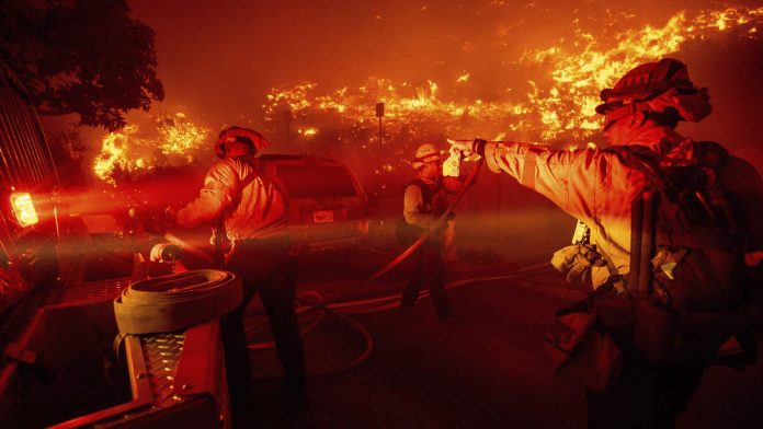
MALIBU (CNS) – The Franklin Fire in Malibu Canyon continues to grow crossing Pacific Coast Highway and spreading to more than 2,200 acres Tuesday, burning in the hillsides near Pepperdine University.
The fire was reported a little before 11 p.m. Monday. A high volume of dry brush in the area and strong Santa Ana winds led to the potential for the blaze to continue to spread rapidly.
The fire has destroyed and damaged homes and structures, but it is unknown the extent of the damage or the number of homes that have burned, according to media reports.
A mandatory evacuation order was issued by the Los Angeles County Fire Department covering the area east of Malibu Canyon Road and south of Piuma Road, as well as the Serra Retreat area.
Damage to buildings was difficult to assess due to heavy smoke and night conditions. Flames reportedly reached the retreat area at 1 a.m. Tuesday and the fire jumped Malibu Canyon Road.
Pepperdine University was reporting power outages and activated a shelter in place protocol for students and staff.
“The fire is not currently threatening the campus, but we are monitoring it closely and (are) in contact with emergency officials,” Pepperdine posted on social media.
At 1:09 a.m. the university posted, “All community members on the Malibu campus are directed to shelter in place in the Tyler Campus Center or Payson Library. Despite any evacuation orders from Malibu city or surrounding areas, the University community should follow University instructions. We do not evacuate the campus even when surrounding areas might — this shelter-in- place protocol is approved by Los Angeles County Fire and executed with their cooperation.”
Pepperdine President Jim Gash announced to students in the library that finals are canceled and normal operations are suspended on campus Tuesday.
“There are numerous LA County Fire Department engines on campus and their helicopters are using the lakes in Alumni Park to pick up water to drop on the fire from above,” Pepperdine University posted.
At 8:30am Pepperdine University officials announced in a statement on social media that a post-daybreak reassessment of conditions has led to a lifting of the “shelter-in-place” protocol at the campus saying, “Campus conditions are safe for members of the community to return to student residences and on-campus homes. The community is strongly encouraged to remain on campus.”
The Franklin Fire is visible from the Malibu campus, according to social media posts from Pepperdine University and students.
“My office is monitoring the #FranklinFire in Malibu. Please follow instructions from public safety officials. Thank you to all first responders working to battle this blaze,” Mayor Karen Bass posted early Tuesday morning.
The Los Angeles Fire Department has three strike teams (15 fire engines with three battalion chiefs) to assist Los Angeles County with the fire, said LAFD spokeswoman Margaret Stewart.
Robert Moran told NBC 4 he was ready to leave his home, where he has lived for 40 years, “in a moment’s notice” if order to do so. “We have a plan, and if you stick to your plan, you’ll be OK,” he said.
Sheriff’s helicopters began water drops in certain areas around 4:30 a.m.
All Malibu schools within the Santa Monica-Malibu Unified School District will be closed Tuesday, the Santa Monica-Malibu School District announced.
Pacific Coast Highway was closed from Carbon Canyon to Corral Canyon.
According to Malibu city officials, the blaze has spread south across PCH to Malibu Road near Webb Way, and across PCH into the Malibu Pier area. Malibu Pier and other structures are impacted. Buildings on Malibu Knolls Rd and Sweetwater Canyon are also impacted. In addition, Malibu Canyon Road from Mullholland Highway to Pacific Coast Highway will be closed to the public and only emergency vehicles will be allowed access.
Mandatory evacuations were issued in Malibu and include Malibu Pier, Malibu Village Mall, City Hall, and Malibu Colony Plaza, the Los Angeles Times reported.
Evacuations warnings are in place:
— East of Las Virgenes between Mulholland Highway to the north and Piuma Road to the South.
— Between Stunt Road to the north and Los Flores to the South.
— East of Carbon Beach Terrace, West of Old Malibu Road, North of Pacific Crest highway to the evacuation order boundary.
–Malibu Canyon Road, from Piuma Road to Pacific Coast Highway
A shelter is set up at Palisades Recreation Center, 851 Alma Real Drive in Pacific Palisades.
Animal shelters are set up at Agoura Animal Care Center in Agoura Hills and Pierce College in Woodland Hills.
According to the Associated Press, north to northeast winds were forecast to increase to 30 to 40 mph with gusts up to 65 mph expected, The National Weather Service Los Angeles office posted on X.
Power to tens of thousands of people had been shut off by Monday night as utilities worked to mitigate the impacts of Santa Ana winds, whose strong gusts can damage electrical equipment and spark wildfires.
Santa Anas are dry, warm and gusty northeast winds that blow from the interior of Southern California toward the coast and offshore. They typically occur during the fall months and continue through winter and into early spring.
The Weather Service issued a red flag warning for high fire risk with a rare “particularly dangerous situation,” or PDS, designation starting at 8 p.m. Monday into Tuesday for Los Angeles and Ventura counties.

Recent Comments