For the latest on ALL fires affecting SoCal CLICK HERE.
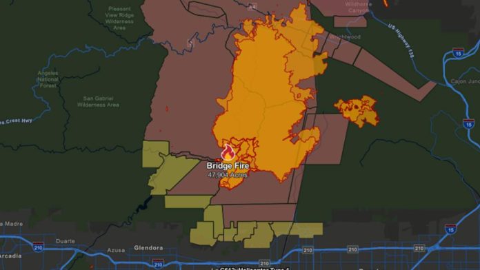
SAN GABRIEL CANYON (CNS) – The Bridge Fire that erupted in the San Gabriel Canyon above Glendora continued to swell in size Wednesday as it chewed through terrain and structures in San Bernardino County, becoming the largest of several blazes burning in Southern California.
The wildfire was reported around 3 p.m. Sunday near the area of East Fork and Glendora Mountain roads, according to officials with the Angeles National Forest. On Tuesday afternoon, the fire was listed at about 4,100 acres, but by early evening, it had exploded in size to more than 34,000 acres.
As of Wednesday morning, Cal Fire reported that the blaze had burned 47,904 acres, fueled by thick brush that carried the flames into San Bernardino County community of Wrightwood and into the Mountain High Ski Resort.
“Last night, the Bridge Fire continued to exhibit extreme fire behavior as it increased over 13,000 acres mainly on the north and east flanks,” according to an early morning Wednesday update from fire commanders. “The top priority for firefighters remained in structure protection and defense within the communities of Wrightwood, Pinon Hills and Mount Baldy.
“Numerous structures in the Wrightwood area have been impacted by the fire, with damage to power infrastructure reported. Once it is safe for damage assessment teams to evaluate, confirmed numbers will be released. Mountain High West and East Ski Resort were also affected by fire activity.”
Fire officials said crews did manage to save an unknown number of homes, and no communication towers were damaged.
The Los Angeles County Sheriff’s Department issued a mandatory evacuation order for the East Fork communities of Camp Williams and River Community on Sunday evening. On Monday, an evacuation order was issued for all residents north of San Antonio Dam up to the Mount Baldy Resort.
Several homes were destroyed in the Wrightwood area, according to reports from the scene, and the intense flames burned ski lifts at the Mountain High Ski Resort.
As of Wednesday morning, evacuation orders were also in place for the following communities:
- Pinon Hills from Wrightwood north to Highway 18 and Beekley Road west to L.A. County
- Lone Pine Canyon from the community of Wrightwood to Highway 138/Lone Pine Canyon Road south to the forest
- Entire community of Wrightwood
- East Fork communities of Camp Williams Resort (café, mobile home park, campground) and River Community (near the resort)
Evacuation warnings were issued Tuesday night for northern Claremont as a precaution, San Antonio Heights and Upland from the foothills south to the I-210, and Pinon Hills from Wrightwood north to Highway 138 and Lebec Road west to L.A. County. The southeast portion of the Bridge Fire continues to burn in northern Claremont, the city of Claremont announced. If you live in this area, check your status HERE.
Road Closures:
- Highway 39
- East Fork Road
- Glendora Mountain Road
- Glendora Ridge Road
- Mount Baldy Road at Shinn Road
- San Gabriel Canyon and East Fork San Gabriel River
- SR-138 closed from Lone Pine to Beekley Road
- SR-2 closed from Big Pine to SR-138
An evacuation center was established at the Jesse Turner Center, 15556 Summit Ave., in Fontana, and the Hacienda Heights Community Center, 1234 Valencia Ave.
Other evacuation centers are at:
- San Bernardino County Fairgrounds: 14800 Seventh St., Victorville
- Pomona Fairplex: 601 W McKinley Ave., Pomona (Enter Gate 3, corner of McKinley and White)
Animal evacuation centers are at:
- Devore Animal Shelter (pets/livestock): 19777 Shelter Way, San Bernardino. Call 909-386-9820, or after hours: 800-472-5609.
- Palmdale Animal Care Center (small animals): 38550 Sierra Highway, Palmdale.
- Lancaster Animal Care Center (small animals): 5210 W. Ave. I, Lancaster.
- Antelope Valley Fairgrounds (large animals): 2551 W. Ave. H, Lancaster. Call 562-706-8581 prior to arrival.
“The safety of our community members is our number one priority, and we will continue to assist residents in any way that we can. We encourage all residents in the affected areas who have been given an order to evacuate to please listen to the orders. If we’re asking you to evacuate, there is no property worth risking your life for,” Los Angeles County Sheriff Robert G. Luna said.
High winds and low humidity are aiding the spread of the fire, Cal Fire said.
East Fork Road at Highway 39 was closed along with Glendora Mountain and Glendora Ridge roads. The California Highway Patrol also closed Highway 39 at the mouth of the canyon due to vehicle congestion. Mount Baldy Road was also closed at Shinn Road.
Forest visitors were being evacuated from the area, the Angeles National Forest announced on social media.
No injuries were reported.
The cause of the fire was not immediately known.

Recent Comments